Caspian Sea: Countries, Map and Legal Status for UPSC
UPSC Planner Editorial Team
Summary
Five countries border the Caspian Sea: Russia, Kazakhstan, Turkmenistan, Iran and Azerbaijan. It is the world's largest enclosed body of water, has no natural outlet, and is governed by the 2018 Aktau Convention, which gives it a special legal status that is neither a plain sea nor a plain lake.
Five countries border the Caspian Sea: Russia, Kazakhstan, Turkmenistan, Iran and Azerbaijan. It is the world's largest enclosed body of water, it has no natural outlet to the ocean, and its surface lies below sea level. In 2018 the five states signed a Convention that gives it a special legal status. UPSC tests this topic through map questions (which countries border it), static geography (why it is called a lake) and current affairs (the Convention).
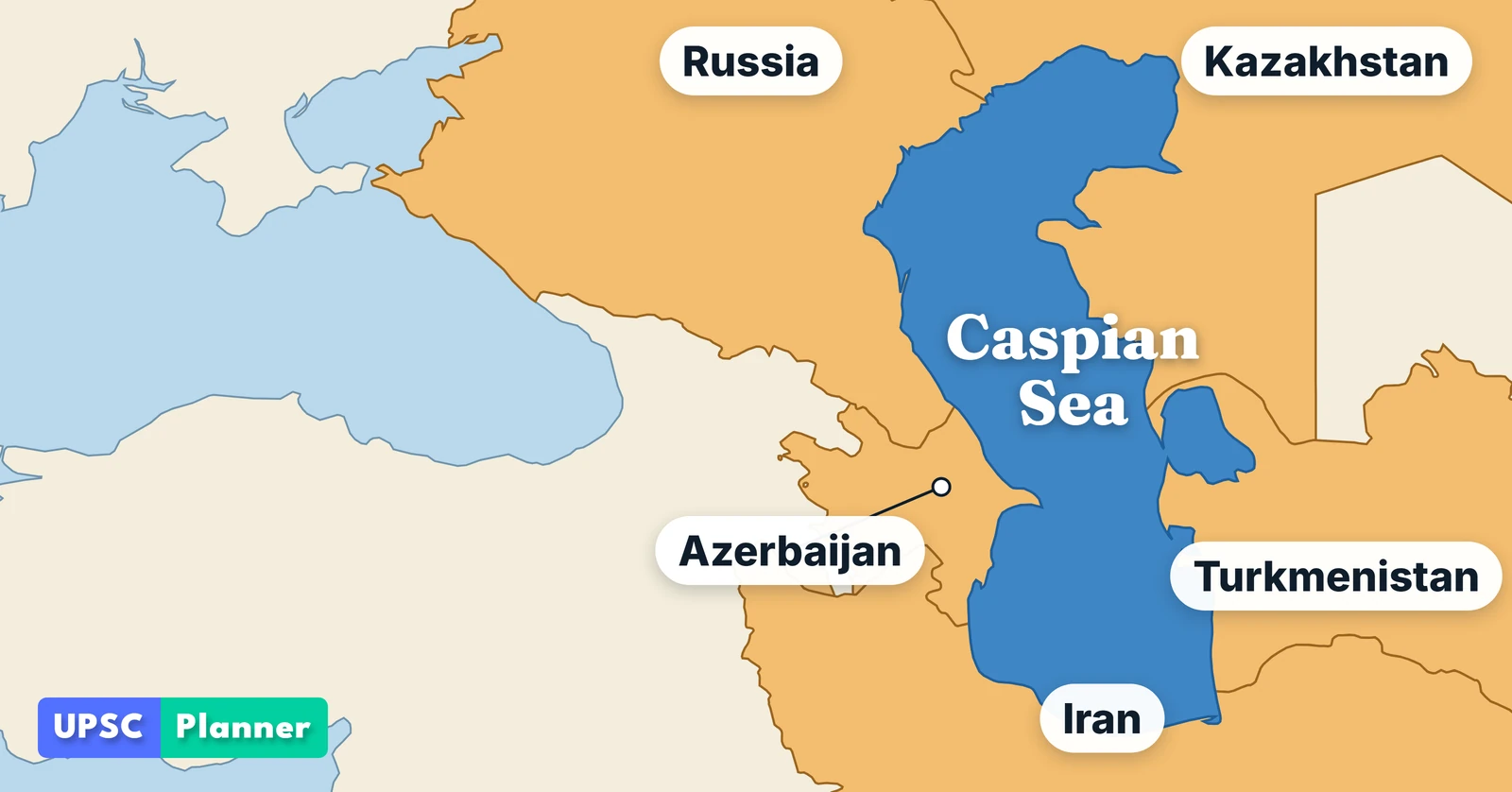
Map: UPSC Planner. Base map data: Natural Earth (public domain).
Which countries border the Caspian Sea?
The Caspian Sea has five littoral states. A littoral state is a country with a coast on that body of water.
| Country | Capital | Position on the Caspian coast |
|---|---|---|
| Russia | Moscow | North-west |
| Kazakhstan | Astana | North-east |
| Turkmenistan | Ashgabat | South-east |
| Iran | Tehran | South |
| Azerbaijan | Baku | South-west |
The five littoral states are named in the preamble of the Convention on the Legal Status of the Caspian Sea. Kazakhstan's capital is Astana again since September 2022, after being called Nur-Sultan from 2019.
Is the Caspian Sea a sea or a lake?
It is often called the world's largest lake, because land surrounds it on every side. It is also called a sea because of its size. The secretariat of the Tehran Convention describes it as an enclosed, land-locked water body.
For the exam, remember this:
- It is the world's largest enclosed (landlocked) body of water.
- The 2018 Convention does not call it a lake. Article 1 defines "the Caspian Sea" as the body of water surrounded by the land territories of the five parties, and then gives it a special regime of its own (see below).
Why does the Caspian Sea have no outlet to the ocean?
It is an endorheic basin: water flows in but has no natural way out except by evaporation. Because nothing drains to the oceans, it is a closed system. The Volga-Don Canal links the Volga basin to the Black Sea basin, but it is man-made, so the sea still has no natural outlet.
What is the main source of water for the Caspian Sea?
The Volga, Europe's longest river, is the main source of fresh water. It flows south through Russia and enters the northern Caspian through a large delta. Other rivers, such as the Kura, the Ural and the Terek, supply much less. Published shares of the Volga's inflow differ by source, so do not memorise a percentage.
How far below sea level is the Caspian Sea?
The Caspian's surface lies below the level of the oceans. The Convention itself fixes its reference line at the multi-year mean level of minus 28.0 metres on the 1977 Baltic Sea Level Datum (Article 1, "normal baseline"). The actual level rises and falls over the years, so quote the direction (below sea level) rather than one exact figure.
What is the 2018 Caspian Convention?
The Convention on the Legal Status of the Caspian Sea was signed at Aktau, Kazakhstan, on 12 August 2018 by the five littoral states. It does not treat the Caspian as an ocean sea or as a simple lake. It sets up its own zones:
| Zone | What it means | Article |
|---|---|---|
| Internal waters | Waters on the landward side of the baseline | Articles 1 and 5 |
| Territorial waters | Sovereignty of the coastal state, up to 15 nautical miles from the baseline | Article 7 |
| Fishery zone | 10 nautical miles beyond the territorial waters, with exclusive harvesting rights | Article 9 |
| Common maritime space | Water outside the fishery zones, open to all five parties | Articles 1 and 5 |
| Seabed sectors | The seabed and subsoil are divided into sectors by agreement between neighbouring and opposite states | Article 8 |
The outer limit of each state's territorial waters is its state border (Article 7).
Is the Convention in force? Not yet, as far as published reports show. Under Article 22 it enters into force when the Depositary, Kazakhstan, receives the fifth instrument of ratification. Reports in 2026 say Iran is the last state still to ratify: its cabinet sent the Convention to parliament in July 2026, as reported by the Times of Central Asia. Check the latest status before an exam, because it can change.
High-yield points for UPSC Prelims
- Five littoral states: Russia, Kazakhstan, Turkmenistan, Iran, Azerbaijan.
- World's largest enclosed body of water, often called the largest lake.
- Endorheic: no natural outlet except evaporation.
- Main inflow: the Volga, Europe's longest river.
- Surface below sea level; the Convention's reference level is minus 28.0 m.
- Convention signed at Aktau on 12 August 2018; it needs five ratifications to enter into force.
- The Convention divides the water into internal waters, territorial waters, fishery zones and a common maritime space, and divides the seabed into sectors.
Sources
Facts on this page were checked against the sources below on 8 November 2026.
- Convention on the Legal Status of the Caspian Sea (full text), signed at Aktau, 12 August 2018: preamble, Articles 1, 5, 7, 8, 9 and 22.
- Convention text published by the President of Russia.
- Tehran Convention secretariat (UNEP): Caspian Sea region, enclosed basin.
- Britannica: Volga River.
- Al Jazeera: Kazakhstan renames capital Astana (17 September 2022).
- Times of Central Asia: Iran moves to ratify the Caspian agreement (2026).
Practise what you read
Test your geography with UPSC Geography MCQs on UPSC Planner.